Today news
The same in other media
16.09 - 15:01
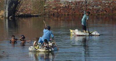
Satellite images reveal nearly 100-km-wide inland lake formed during deadly flooding in Pakistan
Reading now: 449
Pakistan has left death and destruction in a country that is already going through one of its worst economic crises to date.
In satellite images showing the before and aftermath of flooding in Pakistan, the landscape looks completely transformed. Operational Land Imagers aboard NASA’s Landsat 8 and Landsat 9 satellites took images of Pakistan on August 4 and August 28.
The imaging concentrates on the areas which received some of the heaviest flooding damage, along the Indus River in the provinces of Punjab, Khyber Pakhtunkhwa, Balochistan, and Sindh, according to NASA’s Earth Observatory.
What would normally be relatively dry land bordering the river has now turned into a nearly 100-kilometer-wide lake, according to satellite images.
The website covid-19.rehab is an aggregator of news from open sources. The source is indicated at the beginning and at the end of the announcement. You can send a complaint on the news if you find it unreliable.


COVID-19

United States
|
Cases: 46 252 513
Deaths: 750 423
Recovered: 0
|

India
|
Cases: 34 321 025
Deaths: 459 652
Recovered: 0
|

Brazil
|
Cases: 21 835 785
Deaths: 608 235
Recovered: 0
|

United Kingdom
|
Cases: 9 215 683
Deaths: 141 607
Recovered: 0
|

Russia
|
Cases: 8 494 589
Deaths: 237 619
Recovered: 0
|