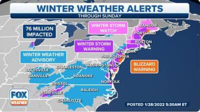
40 million Americans under winter storm watch ahead of weekend nor'easter
nor'easter will develop into a "bomb cyclone" off the East Coast this weekend, placing areas from New England to North Carolina at risk of heavy snow, high winds and coastal flooding beginning Friday evening.The first weather alerts associated with the storm were issued by the National Weather Service on Wednesday.
Winter Storm Watches are in effect along the coast from North Carolina to Maine, including the cities of Boston; Providence, Rhode Island; New York; Philadelphia and Richmond and Norfolk in Virginia.A watch does not mean significant snowfall is guaranteed at that location.
Rather, watches are meant to highlight areas that have the potential to see moderate to heavy snow.Virginia Gov. Glenn Youngkin declared a state of emergency ahead of the winter storm and warned Virginians to stay off the roads if possible.Heavy snow with high winds could down trees and cause widespread power outages."We are very concerned with the forecasted impacts to our Eastern Shore region and have started pre-positioning resources to ensure a timely response to that area," Youngkin said in a statement. "The most important thing everyone can do to minimize the risks is to prepare yourself and your family." WHAT MAKES A STORM A NOR'EASTER?Before the storm's arrival, another blast of arctic air will surge into the Northeast on Friday in the wake of a cold front.
An intensifying low-pressure system will then track near or off the East Coast late Friday through Saturday in response to an upper-level jet stream disturbance punching out of Canada and into the eastern half of the U.S.The cold air will team up with that strengthening area of low pressure to fuel a potentially high-impact winter storm for parts of New England and the coastal.


United States
|
Cases: 46 252 513
Deaths: 750 423
Recovered: 0
|

India
|
Cases: 34 321 025
Deaths: 459 652
Recovered: 0
|

Brazil
|
Cases: 21 835 785
Deaths: 608 235
Recovered: 0
|

United Kingdom
|
Cases: 9 215 683
Deaths: 141 607
Recovered: 0
|

Russia
|
Cases: 8 494 589
Deaths: 237 619
Recovered: 0
|